English
 norsk
norskBlar i tittel Mastergradsoppgaver i geologi
Viser treff 115-134 av 271
-
Jettan, Nordnesfjellet, Kåfjord, Troms – indre geometri og struktur, kinematikk og styrande faktorar av eit ustabilt fjellparti, basert på strukturellanalyse, geomorfologi og overvakingsdata
(Master thesis; Mastergradsoppgave, 2013-11-21)Det ustabile fjellpartiet, Jettan, har blitt studert med ei multidisiplinær tilnærming. Dette inkluderer strukturelle og geomorfologiske analyser i felt, studiar av sann-tid og periodisk overvaking og bruk av kart og digitale elevasjonsmodellar. Formålet har vore å avdekke indre struktur og geometri, kinematikken og kontrollerande faktorar for dei ustabile massane. Det ustabile fjellpartiet er ... -
Kontakten mellom Tromsødekket og Skattøra migmatitt kompleks (Nakkedalsdekket) NØ for Tromsdalstinden : kinematiske indikatorer og metamorfose
(Master thesis; Mastergradsoppgave, 2011-05)Kartlegging av kontakten mellom Tromsødekket og SMC (Nakkedalsdekket) i felt og mikroskopstudiet av tynnslip fra feltområdet, viser en to episoder (DT1 og D2) med deformasjon i Tromsødekket og tre episoder (DS1, DS2 og D2) i SMC. SMC og Tromsødekket viser forskjellig metamorfose før enhetene kom i kontakt i en sen fase av D2 episoden. I Tromsødekket er det observert en tidlig NØ-SV forkortning tolket ... -
Kortejärvi Veiki moraine plateau - a key to the glacial history of northern Sweden
(Master thesis; Mastergradsoppgave, 2020-03-30)In many parts of Scandinavia, the glacial history is more well established than in northern Sweden. The Veiki moraines in northeastern Sweden presumably store information about the Weichselian glaciations. The moraines were formed when stagnant ice was slowly melting under a thick debris cover, forming water filled sinkholes, that were left as elevated ice-walled lake plains when the ice finally ... -
Land sokkel korrelasjon av sprø mesozoiske og paleozoiske forkastninger i et profil over Vestfjordbassenget, Vestvågøya og Ribbebassenget.
(Master thesis; Mastergradsoppgave, 2015-08-19)Denne studien har studert geomorfologi og sprø forkastninger i et profil som strekker seg fra Vestfjordbassenget, over Vestvågøya/Lofotryggen og Ribbebassenget. Det flate slettelandskapet sentralt på Vestvågøya skiller seg ut fra landskapet ellers i Lofoten, som stor sett består av alpint fjellandskap. Slettelandskapet er omgitt av alpine asymmetriske fjell langs kysten i NØ og NV. Fjellenes brattside ... -
Land-sokkel korrelasjon av tektoniske elementer i ytre del av Senja og Kvaløya i Troms
(Master thesis; Mastergradsoppgave, 2011-05)Feltarbeid og analyser av batymetriske-, seismiske- og gravimetriske data er sammenstilt for å korrelere tektoniske elementer i ytre del av Senja og Kvaløya i Troms. Berggrunnen i kystområdene på nordøstlige Senja og Kvaløya i Troms tilhører Vest-Troms gneis region og består av neoarkeiske og paleoproterozoiske tonalittisk gneis og mafiske intrusiver (Kattfjordkomplekset), samt metasuprakrustale ... -
Landform assemblages in inner Kongsfjorden, Svalbard: evidence of recent glacial (surge) activity
(Master thesis; Mastergradsoppgave, 2013-05-15)Swath bathymetry and chirp data have been used to investigate the submarine landform assemblages in inner Kongsfjorden, Svalbard, to reconstruct glacial dynamics during the Late Holocene. Multiple sets of landforms include two types of glacial lineations (groove-ridge features and small, drumlinoid ridges), terminal moraines and associated debris lobes, as well as small push moraines, and indicate ... -
Landskap og prosesser på Vesterålsbanken
(Master thesis; Mastergradsoppgave, 2009-06-12)Oppgaven beskriver og tolker storskalalandskap og geomorfologiske formelementer og prosesser på Vesterålsbanken, som er en del av norsk kontinentalsokkel mellom 68 og 70°N. Svært detaljerte batymetri- og backscatterdata (dybde og akustisk reflektans) er behandlet i GIS (geografiske informasjonssystemer), og resultatene blir presentert i form av kart. Vesterålsbanken er et område som er preget ... -
Last Glacial Maximum – Holocene palaeoenvironment in Bessel Fjord and southwestern Dove Bugt, Northeast Greenland
(Master thesis; Mastergradsoppgave, 2020-05-14)Marine studies reconstructing ice sheet conditions on the Northeast Greenland shelf and adjacent fjords since the Last Glacial Maximum (LGM) are sparse. As a result, the timing and origin of the deglaciation of the ice sheet over marine areas is not well constrained. This thesis aims to improve our understanding of the LGM, deglaciation, and Holocene ice dynamics of the Greenland Ice Sheet (GrIS) ... -
Late Cenozoic development of the mid-Norwegian continental margin – a study of the Naust Formation based on 3D-seismic data
(Master thesis; Mastergradsoppgave, 2020-06-15)The late Cenozoic evolution of the outer continental shelf and slope on the northern part of the mid-Norwegian margin is studied using 3D seismic data. The late Cenozoic stratigraphy is subdivided into four main seismic units: unit A (oldest) to D and correlated to the established stratigraphic framework of the Naust Formation, where the oldest unit in this study correlates to the upper part of Naust ... -
Late Cenozoic erosion in the SW Barents Sea, and its influence on salt movement
(Master thesis; Mastergradsoppgave, 2019-05-15)The late Cenozoic evolution of the southwestern Barents Sea shelf includes periods of uplift, erosion and glaciations. This part of the stratigraphy has been studied using 2D and 3D seismic data, with emphasis on the interplay between uplift, erosion and glaciations and salt movement. The study area comprises the Svalis, Samson and Norvarg domes and the Nordkapp Basin, where halokinesis has been a ... -
Late Cenozoic paleoenvironments in the Veslemøy High area, SW Barents Sea based on 3D- and 2D- seismic data
(Master thesis; Mastergradsoppgave, 2009-05)The aim of this master thesis has been to interpret the Late Cenozoic paleo-environments and the sedimentary processes in the Veslemøy High area, southwestern Barents Sea. Six seismic units and eight seismic unconformities, including the seafloor, are identified in the study area and correlated with previous work in the Sørvestnaget Basin. Submarine channels with a downslope (E-W) orientation suggest ... -
Late Miocene Ice Rafting in the Iceland Sea. Evidence from coarse fraction analysis of ODP Site 907
(Master thesis; Mastergradsoppgave, 2018-05-15)A high-resolution sedimentary record from ODP Leg 151 Hole 907A has been investigated with sedimentological and geochemical methods to study the paleoenvironmental evolution of the Iceland Sea over a 1-Myr time interval in the Late Miocene. Climate deterioration characterizes the Neogene period, culminating in a transition to bipolar glaciations in the Late Pliocene (Thiede and Myhre, 1996). Ice ... -
The Late Paleozoic development of the Ottar basin from seismic 3D interpretation
(Master thesis; Mastergradsoppgave, 2018-05-15)The Late Paleozoic sedimentary environments of the Ottar basin in the SW Barents Sea was studied using five 3D seismic surveys. By the use of seismic stratigraphic analysis and correlation to wells located in close proximity to the study area, the Paleozoic succession has been subdivided into 4 main units: Billefjorden Group (Late Devonian – Mid Carboniferous), Gipsdalen Group (Mid Carboniferous – ... -
Late Paleozoic-Cenozoic fault correlation and characterization of fault rocks in western Troms, North Norway
(Master thesis; Mastergradsoppgave, 2013-05-29)The present work focuses on the mapping and description of onshore brittle fault zones on the SW Barents Sea Margin, within gneisses and granitic intrusions belonging to the West Troms Basement Complex. The description of the brittle structures includes the geometry, kinematics and fault rock characteristics, using DEM satellite imaging, structural field work and a microstructural analysis of the ... -
Late Quaternary tephra stratigraphy and paleoenvironmental reconstruction based on lake sediments from North and Northeast Iceland
(Mastergradsoppgave; Master thesis, 2020-07-12)Due to Iceland’s position in the middle of the North Atlantic, the island is highly sensitive to oceanic and atmospheric fluctuations, which lead to changes in the environment. These fluctuating environmental conditions in addition to Iceland’s high volcanic activity make it a strategic study area for paleoenvironmental and tephra studies. Lake sediments contain information about such past climate ... -
Late Triassic channel systems at the Loppa High, SW Barents Sea
(Master thesis; Mastergradsoppgave, 2015-12-23)The study is based on the 3D seismic dataset (LN09M01). The study area is located in the southwest Barents Sea, south-western flank of the Loppa High. In the SW Barents Sea, the Middle to Late Triassic interval incorporates relatively thick and widespread fluvial system in the Snadd Formation, which is characterized by distinctive abundance of channel bodies of varying shape and extend. During ... -
Late Weichselian and Holocene glacier dynamics and sedimentary processes in and north of the Wijdefjorden-Austfjorden fjord system, north Spitsbergen
(Master thesis; Mastergradsoppgave, 2019-05-16)Multi-proxy analyses (lithostratigraphy, physical properties, XRF core scanning, and grain size analysis) of five sediment cores and high resolution seismic (chirp) data were integrated to reconstruct the Late Weichselian and Holocene sedimentary environments and glacial history in and on the shelf north of Wijdefjorden. Three acoustic units (U1-U3) correlating with three lithostratigraphic units ... -
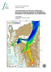
Late Weichselian and Holocene sedimentary processes and glacier dynamics in Woodfjorden, Bockfjorden and Liefdefjorden, North Spitsbergen
(Master thesis; Mastergradsoppgave, 2014-05-31)Abstract Swath bathymetry, high resolution seismic data and sediment cores were analyzed to reconstruct the Late Weichselian and Holocene sedimentary environments and glacier dynamics in Woodfjorden, Bockfjorden and Liefdefjorden, north Spitsbergen. Mega-scale glacial-lineations provide evidence of fast-flowing grounded ice draining the northwestern parts of the Late Weichselian Svalbard Barents ... -
Late Weichselian and Holocene sedimentary processes and environments in Billefjorden, Svalbard
(Master thesis; Mastergradsoppgave, 2007-11)Three sediment cores, swath multibeam bathymetry data and high-resolution seismic data from Billefjorden, Svalbard have been analysed for a better understanding of the Late Weichselian and Holocene glacier activity as well as sedimentary process and glacigenic deposits in the fjord. The data reveal that glacial linear features were generated in the central part of Billefjorden while it was filled ... -
Metamorf utvikling av Skagen-eklogitt, Flakstadøy, Lofoten
(Master thesis; Mastergradsoppgave, 2011-05)Bergartsprøver fra Skagen på Flakstadøy, Lofoten er mikroskopert, analysert ved mikrosonde og gjort geotermobarometriske estimat på, alt for å kunne fortelle om den metamorfe utviklingen for bergartene. Resultatene forteller om en polymorf utviklingshistorie av de proterozoiske bergartene som Flakstadøy er bygd opp av. Flere eklogittforekomster er funnet på øyen, noe som ikke er så overraskende da ...