

 English
 norsk
norskSand waves and sediment transport on the SW Barents sea continental slope
| dc.contributor.advisor | Bünz, Stefan | |
| dc.contributor.advisor | Mienert, Jurgen | |
| dc.contributor.author | Waage, Malin | |
| dc.date.accessioned | 2012-12-11T09:33:08Z | |
| dc.date.available | 2012-12-11T09:33:08Z | |
| dc.date.issued | 2012-11-15 | |
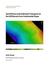
| dc.description.abstract | I study a sand-wave field in ~600 meters water depth on the continental slope offshore Northern Norway. Using multibeam bathymetry data from 2008 and 2011 and P-Cable high-resolution 3D seismic data from 2011, I characterize the field. Sand waves reach up to 6.6 m in height and have wavelengths as large as 140 m. They are mostly asymmetric in shape with the steepest side dipping to the northwest, indicating that current flow over the field is predominantly to the northwest. Larger sand waves (>2 m in height, >100 m wavelength) are observed on topographic highs in the sand-wave field, whereas smaller sand waves (<2 m in height, <100 m wavelength) are present in topographic lows. These topographic lows occur where three ~1-2-km-wide channels cut down the continental slope through the sand-wave field. Seismic data reveal that there are no buried sand waves beneath the seafloor, suggesting that the sand waves are being continually eroded and redeposit at the seabed. Seismic data reveal that the depositional environment over the last ~1 Ma has been largely controlled by debris flows during the glaciations and melt-water plumes and channel formation during the glaciations. High-resolution imaging of the first few meters below the seabed shows that winnowing and associated sand-wave migration is currently the dominant sedimentary process. Data across the study area show that there are no buried sand waves beneath the seafloor. This suggests that the sand waves are being continually eroded and redeposited at the seabed. By measuring the offset of the crest of sand waves in the 2008 and 2011 bathymetry data, I calculate that sand waves migrate from 0 to 3.3 m/yr and have an average migration rate of 1.6 m/yr to the northwest. This migration direction which I directly observe in the bathymetry data is in agreement with the migration direction that I infer from the asymmetry of the sand waves. Integrating these migration rates over the cross section of the sand-wave field, I estimate that sand is transported along the continental slope at a rate of 22.3-118x106 m3/yr. These results provide hard constraints for numerical sand-wave migration models trying to identify the link between ocean currents and sand-wave migration. Furthermore, I show that sand-wave migration has the potential to rapidly move large volumes of sand across the deep water. This movement of sand can complicate drilling and production procedures in the energy industry and may affect slope stability on continental margins around the world. | en |
| dc.identifier.uri | https://hdl.handle.net/10037/4668 | |
| dc.identifier.urn | URN:NBN:no-uit_munin_4385 | |
| dc.language.iso | eng | en |
| dc.publisher | Universitetet i Tromsø | en |
| dc.publisher | University of Tromsø | en |
| dc.rights.accessRights | openAccess | |
| dc.rights.holder | Copyright 2012 The Author(s) | |
| dc.rights.uri | https://creativecommons.org/licenses/by-nc-sa/3.0 | en_US |
| dc.rights | Attribution-NonCommercial-ShareAlike 3.0 Unported (CC BY-NC-SA 3.0) | en_US |
| dc.subject.courseID | GEO-3900 | en |
| dc.subject | VDP::Matematikk og Naturvitenskap: 400::Geofag: 450 | en |
| dc.subject | VDP::Mathematics and natural science: 400::Geosciences: 450 | en |
| dc.title | Sand waves and sediment transport on the SW Barents sea continental slope | en |
| dc.type | Master thesis | en |
| dc.type | Mastergradsoppgave | en |
Tilhørende fil(er)
Denne innførselen finnes i følgende samling(er)

Med mindre det står noe annet, er denne innførselens lisens beskrevet som Attribution-NonCommercial-ShareAlike 3.0 Unported (CC BY-NC-SA 3.0)