| dc.contributor.author | Wickler, Stephen | |
| dc.date.accessioned | 2014-03-24T10:28:13Z | |
| dc.date.available | 2014-03-24T10:28:13Z | |
| dc.date.issued | 2013 | |
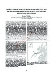
| dc.description.abstract | The Lofoten-Vesterålen archipelago (67°30’ - 69°30’N)
is a chain of mountainous islands dissected by cirques,
glacial valleys, and fjords that extends from northeast to
southwest into the Norwegian Sea (Figure 1). Vesterålen
is the northerly chain of islands and the seven islands
of Lofoten lie to the south. The climate of Lofoten is
mild despite this high latitude location. Temperatures are
strongly affected by northward transport of heat through
oceanic and atmospheric dynamics and the Norwegian
Current flowing directly west of the islands carries warm
water to the high latitudes of northern Norway (Hopkins
1991). Human habitation in this region has always been
dependent on the marine environment with a reliance
on the ocean and coastal areas for subsistence, shelter
and transportation since initial settlement. Lofoten is
situated in the midst of one of the most productive cod
fishing grounds in the North Atlantic and the climate is
also ideally suited for drying and preserving fish, another
factor that helped this region develop as an important
fishing center. | en |
| dc.identifier.citation | Archaeopress (2013), s 63 - 74. | en |
| dc.identifier.cristinID | FRIDAID 1080795 | |
| dc.identifier.isbn | 978 1 4073 11913 | |
| dc.identifier.uri | https://hdl.handle.net/10037/6088 | |
| dc.identifier.urn | URN:NBN:no-uit_munin_5759 | |
| dc.language.iso | eng | en |
| dc.publisher | Archaeopress | en |
| dc.rights.accessRights | openAccess | |
| dc.subject | VDP::Humanities: 000::Archeology: 090::Nordic archeology: 091 | en |
| dc.subject | VDP::Humaniora: 000::Arkeologi: 090::Nordisk arkeologi: 091 | en |
| dc.title | The potential of shoreline and shallow submerged Iron Age and Medieval archaeological sites in the Lofoten Islands, northern Norway | en |
| dc.type | Journal article | en |
| dc.type | Tidsskriftartikkel | en |
| dc.type | Peer reviewed | en |


 English
 norsk
norsk