English
 norsk
norskBlar i tittel Mastergradsoppgaver i geologi
Viser treff 181-200 av 271
-
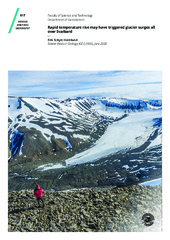
Rapid temperature rise may have triggered glacier surges all over Svalbard
(Mastergradsoppgave; Master thesis, 2020-05-04)Observational and geomorphological records suggest that most glaciers on Svalbard reached their maximum Little Ice Age extents by means of surging. Furthermore, it seems to have happened within just a few decades, suggesting that the rapid concurrent changes in climate might have triggered this widespread surging. The specific precipitation and temperature range of Svalbard seems optimal for glacier ... -
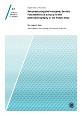
Reconstructing the holocene. Benthic foraminifera as a proxy for the paleoceonography of the nordic seas
(Master thesis; Mastergradsoppgave, 2017-08-01)The benthic foraminifera of two marine sediment cores were studied as a proxy for paleoenvironment reconstructions throughout the Late to Early Holocene. The two cores were sampled in different localities to allow a spatial comparison of changing environments in the Nordic Seas and sampled for benthic foraminiferal assemblages, grain size, IRD, sortable silts and benthic foraminifera isotopes. While ... -
Reconstruction of Holocene Paleoenvironment in Smeerenburgfjorden, northwest Svalbard based on benthic foraminifera and sedimentological investigations
(Master thesis; Mastergradsoppgave, 2015-05-16)Two gravity cores JM06-024-GC3 and JM07-049-GC1 from Smeerenburgfjorden at the northwestern corner of Svalbard have been investigated for the distribution pattern of the benthic foraminiferal faunas. The oxygen and carbon isotope values in benthic foraminifera were analysed and together with other proxy data such as ice rafted debris (IRD), were used in order to reconstruct the paleoceanography and ... -
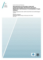
Reconstruction of ice stream retreat and palaeoceanographic development during the deglaciation and Holocene in the Storfjorden Trough, Svalbard. Based on geophysical data, benthic foraminiferal and sedimentological records
(Master thesis; Mastergradsoppgave, 2016-05-15)Here we investigate the retreat of a palaeo-ice stream and the subsequent palaeoceanographic development in the eastern Storfjorden Trough during the deglaciation and Holocene. The results are based on multibeam bathymetric and acoustic sub-bottom data, and a multiproxy analysis of a 14C dated sediment core (including benthic foraminifera, δ13C, δ18O and sedimentology). The ice stream experienced a ... -
Reconstruction of late Holocene paleoenvironment in Kongsfjorden, West Spitsbergen. Based on analysis of benthic foraminifera
(Master thesis; Mastergradsoppgave, 2017-05-15)The benthic foraminiferal fauna of two marine sediment records from the Kongsfjorden Trough and the inner part of Kongsfjorden were analyzed to reconstruct the paleoenvironmental development throughout the last ~ 2000 years. A generally cold period is evident in both records, lasting from ~ 700 to 1400 CE at the Kongsfjorden Trough and from ~ 350 to 1200 CE in the inner part of Kongsfjorden, with ... -
Reconstruction of the bottom current strength of overflow water through the Faeroe-Shetland Channel in relation to climate change during the last 135,000 years
(Master thesis; Mastergradsoppgave, 2018-05-15)The focus of this thesis was to reconstruct the bottom current strength around the Faeroe Islands and relate it to the climate variability over the past 35,000 - 135,000 years and the Holocene, using the piston core, JM11-FI-19PC, from the North-eastern shelf of the Faeroe Islands. The core location is ideal for measuring the overflow from the Nordic Seas, as it is strategically placed on top of the ... -
Reconstruction of the Kråknes landslide event, Alta
(Master thesis; Mastergradsoppgave, 2021-05-15)On June 3rd, 2020 a major quick clay landslide occurred at Kråknes in Alta municipality, Northern Norway. The landslide event destroyed eight buildings and was estimated to be 650 meters wide and 40 meters high. Two days later, another landslide occurred, this time causing the old E6 road above the previous landslide area to slip out towards the sea. People lost cabins and other valuable possessions, ... -
Reconstruction of the paleocenaography west of Lofoten during the Last Glacial Maximum
(Master thesis; Mastergradsoppgave, 2021-05-15)<p>A 513 cm long sediment core from the Lofoten Contourite Drift at the continental slope west of the Lofoten Islands has been investigated. The aim was to reconstruct the paleoceanography during the Last Glacial Maximum (LGM). The Lofoten Contourite drift was relatively protected by the Lofoten Islands from the ice streams of the Scandinavian Ice Sheet during LGM. <p>An age model was constructed ... -
Reconstructions of paleoceanography and ice retreat based on benthic foraminifera, stable isotopes and sedimentological investigations from the northwestern Barents Sea south of Nordaustlandet, Svalbard
(Master thesis; Mastergradsoppgave, 2016-07-12)One gracity core NP05–11–49GC was retrieved from a 320 m water depth in the central part of Erik Eriksen Strait, south of Nordaustlandet, northwestern Barents Sea. The core was investigated for benthic foraminiferal distribution patterns, stable isotopes and sedimentological parameters in order to reconstruct the Late Weichselian deglaciation and Holocene paleoenvironment and paleoceanography of the ... -
The regional Cretaceous development of the southeastern part of the Norwegian Barents Sea- from seismic interpretation
(Master thesis; Mastergradsoppgave, 2018-05-15)This study sheds new light on the regional Cretaceous development of the southeastern part of the Norwegian Barents Sea. The study area is in the former disputed area between Norway and Russia, which after the agreement on the new borders in 2010 was opened to petroleum activity in 2013. Consequently, the southeastern Barents Sea is still a frontier area with less scientific knowledge, compared to ... -
Regional structural analysis of rock slope failure types, mechanisms and controlling bedrock structures in Kåfjorden, Troms
(Master thesis; Mastergradsoppgave, 2018-05-15)Unstable areas producing rock slope failures come with large consequences. The understanding of why and where they might occur is necessary to mitigate damage and prevent casualties. A total of 133 unstable rock slopes have been detected in Troms, Northern Norway, evidencing that a great focus on these geohazards is important. This study has focused on seven unstable rock slopes in Kåfjorden, Troms, ... -
The regional upper Paleozoic development of the SE part of the Norwegian Barents Sea - from seismic interpretation
(Master thesis; Mastergradsoppgave, 2018-05-15)This thesis focuses on the Barents Sea South East (BSSE), and the overall goal has been to investigate the regional upper Paleozoic development in the SE part of the Barents Sea. After more than four decades of negotiation between Norway and Russia, a delineation agreement came in effect in 2011. Today, the area known as BSSE is opened up for petroleum operations. As part of the opening of the BSSE, ... -
Rekonstruksjon av paleomiljø i Kongsfjordrenna, vest for Svalbard, de siste ~11 800 år, basert på bentiske foraminiferer og sedimentologiske undersøkelser
(Master thesis; Mastergradsoppgave, 2007-11-15)Sedimentkjerne NP05-11-21GC fra Kongsfjordrenna vest for Spitsbergen er analysert for å kartlegge utviklingen av paleomiljø de siste ~11 800 år. Analysene er basert på undersøkelser av bentiske foraminiferer og sedimentologiske egenskaper. Kjernen er 5,15 meter lang og 104 prøver er analysert med hensyn på fauna, droppstein og kornfordeling. Sedimentenes fysiske egenskaper er målt ved hjelp av en ... -
Relationship between fluid leakage and faulting along the western and northern margin of the Hammerfest Basin
(Master thesis; Mastergradsoppgave, 2014-05-15)Abstract This thesis focuses on establishing a causal relationship between potential fluid sources, fluid migration pathways, shallow gas accumulations and potential gas hydrates in the western part of the Hammerfest Basin, SW Barents Sea. Two 3D seismic surveys (LN0901 and ST8320R00) were used to map fluid flow, stratigraphy, structure, fluid flow and other fluid-related features along the western ... -
Relationship between glacial erosion and fluid flow inferred from 3D seismic data : SW Barents Sea
(Master thesis; Mastergradsoppgave, 2012-06-05)This Master thesis investigates the relationship between glacial erosion, glaciotectonically displaced sediment blocks and indications of fluid flow and shallow gas accumulations in buried glacial sediments of the south-western Barents Sea margin. The thesis is based on two three-dimensional (3D) seismic datasets, NH98003 and EL0001, the two-dimensional (2D) seismic survey NH9702 and exploration ... -
The relationship between shallow anomalies and gas-flaring on the flank of the Nordkapp Basin in the SE Barents Sea
(Master thesis; Mastergradsoppgave, 2020-05-18)This study investigates the north-east-subbasin of the Nordkapp Basin in the Barents Sea. Main focus has been on mapping shallow seismic anomalies from 3D data, their potential association with faulting and sub-surface structures, and further to compare the occurrence of seismic anomalies to possible gas-flares above the seabed from water column data. The stratigraphic intervals from Triassic to ... -
Relationships between metamorphism and deformation in the Nordmannvik nappe, south of Lyngseidet: a focus on high grade relics
(Master thesis; Mastergradsoppgave, 2013-05-13)The Nordmannvik nappe (Lyngen fjord, northern Norway) is a high grade tectonic unit dominated by mylonitic garnet-kyanite-mica gneisses, with additional calc-sillicates, mafics and high grade relics. The unit was principaly deformed during the Scandian event of the Caledonian orogeny, reaching at least an upper amphibolite facies. A metamorphic peak, set at a minimum of 750°C / 0.9 GPa, has been ... -
The rock slope failures at Låvan and Dusnjarga, Northern Norway. A comprehensive Quaternary, morphological and structural analysis
(Master thesis; Mastergradsoppgave, 2020-05-15)Rock avalanches and subsequent displacement waves represented the deadliest natural disaster in Norway in the past century. The two deep-seated and unstable slopes Dusnjarga and Låvan in Troms county (Norway) are clearly defined by morphological deformation features. Due to the steep fjord setting, a potential catastrophic rock avalanche could pose a severe threat to people and infrastructure along ... -
Rockfall and snow avalanche impact dynamics for road protection design at Svarthola, Senja. A hazard evaluation aided by numerical models and physical formulas
(Master thesis; Mastergradsoppgave, 2021-05-14)Rockfalls and snow avalanches are a major natural hazard and common phenomenon in mountainous areas in Norway, endangering people and infrastructure. Svarthola, on Fv 862, Senja, is a 100 m long unprotected stretch of road that experiences a high frequency of mass movements. The road is situated at a tunnel portal, between a 100 m high cliff and the fjord. As such, it is the only short access route ... -
Rockfall hazard assessment based on semi-automatic point cloud analysis from UAV data
(Master thesis; Mastergradsoppgave, 2018-12-29)Slettind in Flaktstad municipality, Lofoten in Nordland, has numerous rockfalls throughout the year. Rockfalls hit Fv 805 on a weekly basis, and it is estimated the most dangerous road in Nordland county. A rock avalanche hit the road winter 2017 closing it for 2 weeks, and isolating the small village Myrland. Statens Vegvesen consider to build a tunnel to protect the road but the failure mechanisms ...