English
 norsk
norskBlar i tittel Mastergradsoppgaver i geologi
Viser treff 83-102 av 272
-
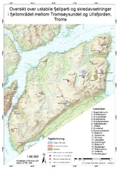
Geomorfologisk og strukturgeologisk undersøkelse av ustabile skråninger og skredavsetninger i fjellområdet mellom Tromsøysundet og Ullsfjorden i Tromsf
(Master thesis; Mastergradsoppgave, 2017-05-15)Fjellskred er den naturkatastrofen i landet som kan gi høyest konsekvenser, og Troms fylke har flere registrerte ustabile fjellsider enn noe annet sted i landet. Dette gjør også at mange skred og ustabile fjellsider kan studeres innenfor et relativt lite geografisk område. Hensikten med denne oppgaven er å finne sammenhenger i parameterer i berggrunn og topografi som er med å initiere bevegelse i ... -
Geomorfologisk og strukturgeologisk undersøking av ustabile skråningar og skredavsettingar. Regional analyse av fjellområdet mellom Tromsøysundet og Ullsfjorden -Troms, Norge.
(Master thesis; Mastergradsoppgave, 2017-05-15)Samandrag Troms er det fylket i landet med flest registrerte ustabile fjellsider. Ved å kartlegga større områder for ustabile fjellparti og historiske skred, kan ein gjera ei regional analyse. Dette kan bidra til å forstå dei styrande faktorane for utrasing i eit regionalt perspektiv. Denne avhandlinga omhandlar hovudsakleg geomorfologi, og er skreve parallelt med Andreas Grumstad som har omtala ... -
Geomorfologisk undersøkelse av skredvifter i Indre Kjosen, Lyngen, Troms, med fokus på snøskredavsetninger
(Master thesis; Mastergradsoppgave, 2017-05-16)Skred er et utbredt faremoment i Troms og utgjør en overhengende trussel for bebyggelse så vel som for infrastruktur. Skredene kan skade mennesker og menneskelige interesser, og det investeres store summer i sikringstiltak. Skredprosesser er med på å utvikle landskapet og kan spores på bakgrunn av mer eller mindre karakteristiske landformer, elementer og avsetninger, kalt skredindikatorer. ... -
Geomorfologiske og sedimentologiske undersøkelser av kolluviale vifter i Storfjord og Signaldalen, Troms. Prosesser, overflateformer og avsetningshistorie
(Master thesis; Mastergradsoppgave, 2007-08-16)Kolluviale vifter er en utbredt landskapsform i Nordnorske fjell, men er lite studert. Det er utført geomorfologiske og sedimentologiske undersøkelser av tre kolluviale vifter i Storfjord og Signaldalen, Troms. Under siste istids maksimum var området dekket av is. Studieområdet ble deglasiert mellom 9800- 9300 år BP, og denne perioden regnes som starttidspunktet for vifteutbyggingen. Sedimentasjonsraten ... -
Geomorfologiske undersøkelser av skråningsavsetninger og -prosesser i Kåfjorddalen i Troms
(Master thesis; Mastergradsoppgave, 2019-12-13)Hovedformålet med denne oppgaven er å beskrive og tolke skredavsetninger og -prosesser i den sørvestre dalsiden i Kåfjorddalen i Troms. I tillegg blir det gjort en overordnet vurdering av hvordan sedimenttransporten kan ha vært gjennom holocen og hvordan skredaktiviteten forventes å bli som følge av klimaendringene. Fjorten skredvifter er beskrevet og tolket. Beskrivelsene og tolkningene av ... -
Geomorphological study of the rock-slope failure at Adjet, Storfjord, Troms
(Master thesis; Mastergradsoppgave, 2015-06-06)Norway is known for its steep mountains and many fjords. This landscape provides the potential for large rock-slope failures (RSFs) which, in turn, can cause other catastrophic hazards, e.g. tsunamis. In Troms County, northern Norway, many RSFs are found east and west of the Lyngen peninsula, within an area of discontinuous permafrost. The RSF at Adjet is located southeast of the Lyngen peninsula. ... -
Geophysical investigation of faults and fractures in Upper-Palaeozoic carbonate build-ups at the Loppa High, SW Barents Sea
(Master thesis; Mastergradsoppgave, 2010-05)During previous studies of the Upper-Palaeozoic carbonate build-ups at the Loppa High in SW Barents Sea, a connection between locations of the build-ups and syn-depositional faults was observed. This thesis is studying this relationship in detail, applying the Ant-tracking semi-automated method for detection of faults. To my knowledge, this relatively new method has not been used in the Barents Sea ... -
Glacial dynamics and fluid flow processes in Bjørnøyrenna and the Loppa High area, SW Barents Sea
(Master thesis; Mastergradsoppgave, 2020-05-15)During the Late Weichselian glaciation, the Bjørnøyrenna ice stream was the main outlet of the Barents Sea Ice Sheet. In this thesis, a 3D seismic dataset from the Loppa High, located in the main ice stream trunk, has been used to study the glacial sediment package, revealing details on pastglacial dynamics, fluid flow processes and gas hydrate formation. Three seismic horizons have been interpreted: ... -
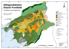
Glacial history and forefield development of Aldegondabreen since the Little Ice Age maximum extent
(Master thesis; Mastergradsoppgave, 2018-05-15)A geomorphological map has been produced to investigate the glacial history of Aldegondabreen, a small land terminating valley glacier located on the western coast of Spitsbergen. The glacier has changed its dynamic from a tidewater glacier into a land-terminating glacier during the last advance/retreat cycle, and the focus is therefore to reconstruct the glacial history of this cycle. The map ... -
Glacial history and geomorphology of Trygghamna, western Svalbard
(Master thesis; Mastergradsoppgave, 2017-05-15)This study investigates Trygghamna, a small fjord on the western coast of Spitsbergen, Svalbard. In order to investigate its glacial history, high-resolution aerial images and swath bathymetry are used to produce a detailed geomorphological map of the area, with a focus on the Neoglacial extent of the three largest glaciers in the fjord, Protektor-, Harriet- and Kjerulfbreen. The landforms are ... -
Glasial geomorfologi og deglasiasjon av Nordkappbanken-området, sørvestlige Barentshav, basert på 3D- og 2D-seismiske data
(Master thesis; Mastergradsoppgave, 2008-05-15)Formålet med oppgaven har vært å gi en geomorfologisk analyse av havbunnen og grunne begravde flater i de glasigene sedimentene i området rundt Nordkappbanken i det sørvestlige Barentshavet for å øke vår kunnskap om deglasiasjonen i dette området. Datagrunnlaget har vært fem 3D-seismiske datasett i kombinasjon med et tett nett av regional 2D-seismikk. Oppgaven viser at havbunnen i det sørvestlige ... -
Grounding-line fan formation during an Early Holocene readvance of Aldegondabreen, Svalbard.
(Mastergradsoppgave; Master thesis, 2021-12-10)In this study, two ridge-shaped cross-valley sedimentary landforms, in the lower forefield of Aldegondabreen, a small valley glacier on the west coast of Spitsbergen, Svalbard, were studied to reconstruct the Holocene glacial history of Aldegondabreen prior to the Little Ice Age. Sedimentological and geomorphological methods were used in conjunction with radiocarbon dating to examine the sediments ... -
Heinrich events of the late Pleistocene; evidence from a sediment core west of Jan Mayen. An analogue to present day ice sheet collapse?
(Master thesis; Mastergradsoppgave, 2017-05-15)A thorough lithological investigation of deep sea sediment core HH13-100GC has been undertaken, in order to investigate the climate and oceanographic fluctuations of the last glacial epoch. The cause of Heinrich events has remained an enigma ever since the discovery of Heinrich layers in the North Atlantic in the 1980s. Through a combination of XRF and X-ray imagery, geotechnical property investigation, ... -
High-resolution study of selected Dansgaard- Oeschger events and Heinrich event 4 42,189–33,393 cal. years BP. Gravity core JM11-FI-15GC from Fugløy Ridge, northeastern Faeroe Islands Margin
(Master thesis; Mastergradsoppgave, 2015-05-15)The focus of this thesis was selected Dansgaard-Oeschger (D-O) events and Heinrich event 4 (H4). A gravity core, JM11-FI-15GC, from Fugløy Ridge was used for the investigation. The location of the core site is important due the fact that the Faeroe- Shetland Channel is a key area in understanding the changes in circulation during the last glacial period. In total there were eighteen D-O climatic ... -
Holocene climate variability in the Norwegian current and North Cape current inferred from benthic stable isotope records
(Master thesis; Mastergradsoppgave, 2006-06-14)The Malangenfjord, with its deep sill and good hydrological communication with the Norwegian Sea, has been the site for a high resolution paleoclimatic investigation. By using benthic foraminifera and stable isotopes from a marine sediment core, this study will reconstruct the changes in inflow of warm Atlantic Water at a high-latitude setting.<br><br> Radiocarbon dating has give ages between 8000 ... -
Holocene Glacial Dynamics of the Barentsøya ice cap, Svalbard
(Master thesis; Mastergradsoppgave, 2018-05-13)This study investigates the glacial dynamics of Barentsjøkulen, a small ice cap located on Barentsøya, Svalbard. In order to reconstruct Barentsjøkulen’s glacial history, three geomorphological maps of the glacier forefields of its main outlet glaciers, Besselsbreen, Duckwitzbreen and Freemanbreen, were created. The maps cover a total area of ca. 117 km2 and were generated based on swath bathymetric ... -
Holocene sedimentary environments in Smeerenburgfjorden, Spitsbergen
(Master thesis; Mastergradsoppgave, 2012-11-15)Multi-proxy analyses of six sediment cores (including lithostratigraphy, physical properties, granulometric analyses, and XRF scanning), and analyses of swath bathymetry and chirp data were integrated to elucidate the Holocene sedimentary processes and palaeoenvironments in Smeerenburgfjorden, northwest Spitsbergen. Three basins separated by two sills define the present-day large-scale bathymetry. ... -
How is the carbon and oxygen isotope composition of foraminiferal tests influenced by methane seepage?
(Master thesis; Mastergradsoppgave, 2019-06-05)The focus of this thesis is how methane seepage influences foraminifera l tests. Specifically, How how carbon and oxygen isotopes in planktic foraminifera tests are influenced by methane seepage. The study area is Vestnesa Ridge were four gravity cores were collected during a CAGE cruise in 2013. The cores were taken both from the southern side, where flares has have been recorded, and from the ... -
Hydrothermal Cu-Zn mineralization at Vanna, West Troms Basement Complex: A geochemical analysis of Archean and Proterozoic rocks with focus on sulfide genesis
(Master thesis; Mastergradsoppgave, 2014-08-16)The hydrothermal Vannareid Cu-Zn mineralization is located on the island of Vanna, West Troms Basement Complex. It was discovered in 2008 and was subject of Store Norske Gull AS' exploration project in 2012. The mineralization is situated along the border between the Archean granitoid basement intruded by tholeiitic and calc-alkaline dykes, and the overlying Neoproterozoic metasedimentary rocks of ... -
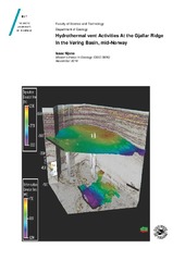
Hydrothermal Vent Activities At the Gjallar Ridge in the Vøring Basin, mid-Norway
(Master thesis; Mastergradsoppgave, 2014-11-21)The 3D seismic enable a better understanding of phreatomagmatic activity that occurred at the Gjallar ridge in the Vøring basin, mid-Norway. Structures associated with this activity were imaged and a causality relationship was established. Those structures included hydrothermal vent complexes, sill complexes and faults. The Kai formation significantly affected by polygonal faulting that were likely ...